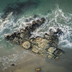
Ben Broady’s adventurous upbringing in northern Western Australia set him up for his career as a landscape photographer, which has taken off as steeply as the drones he uses to spectacular effect.
Ethereal
It’s clear from your photography and drone work that you have a deep understanding of the wilds of northern Australia, particularly the Kimberley region. What’s the background to that?
I grew up in the 1980s in Wyndham, the northernmost town in Western Australia. Both my parents worked at the meatworks there when it was one of the largest in the Southern Hemisphere. Until it closed in 1985, Wyndham had markets, parades, dancing balls, horse races, a speedway… It was a bustling town. We continued living there until 1990 in what had been a meatworks house while my dad worked for a fuel distribution company. My friends and I had great fun playing in, on, and around the derelict meatworks after school, in the freezer rooms, the kitchen, using ladders to get on the rooves. Basically we were wrecking the place, but nobody cared. It was very reckless and unsafe, and I’m not sure what our parents were thinking. Back then, we didn’t tell them much.
The township is surrounded by marsh and we spent a lot of time there too, playing in the mangroves, driving buggies and getting bogged. There was also the wharf to play on and under, because Wyndham was, and still is, a port town. If you fell in, you were waist-deep in mud – and then you had crocodiles to deal with.
It’s a very grand landscape all round, and what I remember is an incredible amount of freedom. Maybe too much. I don’t think you’d get away with it these days.
Emu and the elephant
Were you interested in photography back then?
Not at all. We left Wyndham for Kununurra [100km to the southeast] when I was 12, and that’s where I experienced freshwater country. The lagoons and Lake Kununurra, the pumphouse, waterfalls in the wet season. At 21, I went travelling overseas and when I came back six years later, I drove road trains and worked in mining and sandalwood. It wasn’t until 2012 that I picked up an amateur camera and started getting some popularity on social media.
In 2017, I became professional. I was the harvest manager for a sandalwood company and doing photography after work. It got to the point where it was one or the other, and I was encouraged by my employer – which was amazing – and the local small business support groups. It was a natural progression due to word of mouth in a small town. I never really advertised. But the phone hasn’t stopped ringing. It’s been incredible.
It’s very difficult to make a living as a landscape photographer. How have you made that work for you?
I’m very versatile, a jack of all trades. If I had to choose to master one thing, it would be going out into the bush – just me and the dog and a swag – and taking time-lapse frames of the landscape in low light and at night. That’s where my passion lies. But I’ve done everything from local NGOs, government agencies, tourism, agriculture, mining, small business and real estate, to working on movies around Australia.
Paradigm
When and how did the drone work start?
I first picked up a drone in 2016, and the following year I did the drone work for the first season of the ABC TV series Mystery Road. I’d heard whispers they were coming to town, but it was they who contacted me. We had a meeting and they said, ‘How do you feel about being a paid intern and the drone pilot and working on the camera team?’ That was massive. It’s a great series and it had awesome people working on it. In 2022 I was the drone pilot and time-lapse director of photography for Our Law [an SBS/NITV documentary series about Indigenous police officers and cadets].
What’s the relationship between your still-camera work and using a drone?
My photos and video evolved at pretty much the same time, but I would never take a single frame from a drone video and use it as a still. I’d take the time to set up the frame and take a proper RAW image to get professional-standard resolution.
I have two hybrid Sony A7 cameras that shoot both photos and video, and I have two Mavic 3 drones [which come with a Hasselblad camera onboard]. I also have a time-lapse dolly and slider, a panoramic head [for stitching together multiple-shot panoramas], a DJI Ronin for stabilising video, and filters for video and landscape photography.
Ord Gorge and Lake Argyle
But you do use your drones to create still images. For example, for your stunning panorama ‘Ord Gorge and Lake Argyle’. How did you do that?
That panorama is effectively a 180-degree view I did in 2018. It was 40 images in three or four rows, shot and stitched from a drone. I was on the ground, in trees centre-left [in Lake Argyle Tourist Village], and I was looking at one small part of the whole image at a time on a screen.
I think it’s fair to say I’m something of a pioneer at doing this in Australia. The drone stays in one position in the sky [the equivalent of a camera on a tripod on the ground] and I take a photo, then move the framing to the right, take another photo, move to the right, and so on. Then I come down a row and do it again. To make sure everything can stitch together, I make the shots overlap by about 30%. The stitching is done automatically and doesn’t take long, but it all looks weird and warped, so I have to go into Photoshop and push and pull, stretch and unstretch, to make it look normal. I also do colour grading, and dodging and burning, lightening highlights and darkening shadows. The final file is about 100MB.
It would be impossible to capture an image like ‘Ord Gorge and Lake Argyle’ in one frame. It’s incredible geography and I’m trying to capture as much of it as possible in one image and show how the different parts relate to each other. It’s all part of showing people how beautiful, majestic and largely untouched the Kimberley is, because a lot of people don’t know.
Mandangala Dawang
On your website, with the drone image ‘Mandangala Dawang’, you explain that this landform is part of the Ragged Range, which is an integral part of the Jaliwang barramundi dreaming story, the most significant Dreamtime creation story for the East Kimberley. How important is this kind of traditional Aboriginal context to you?
It’s extremely important. I don’t know it all, but I’ve been very privileged to go out on country with elders and hear the stories of how the landscape came to be. They revere this country as though it’s a deity, a living organism, and I’ve learnt from them how to be respectful when I’m out on country.
I heard the barramundi dreaming story from Miriwoong man Ted Hall, who runs Luridgii Tours out of Kununurra. It starts at Darram [Bandicoot Bar], at the base of the Ord River Diversion Dam, and finishes at the Argyle Diamond Mine, where the barramundi left its scales – the diamonds. Aboriginal people have always known about the diamonds, but they didn’t care about them. They cared about the land. Which, now that the mine has closed, they want back in a rehabilitated state.
And I believe that relates to your next job.
It does. Tomorrow I’ll be driving out to the mine site [185km from Kununurra], where they’re in the latter stage of demolition. Since Rio Tinto closed the mine in 2020, I’ve been going out every month or two and documenting it for the demolition company.
King River
To see more of Ben Broady’s photography, visit www.benbroady.com.
Article by Steve Packer
Excerpt from Photo Review Issue 96